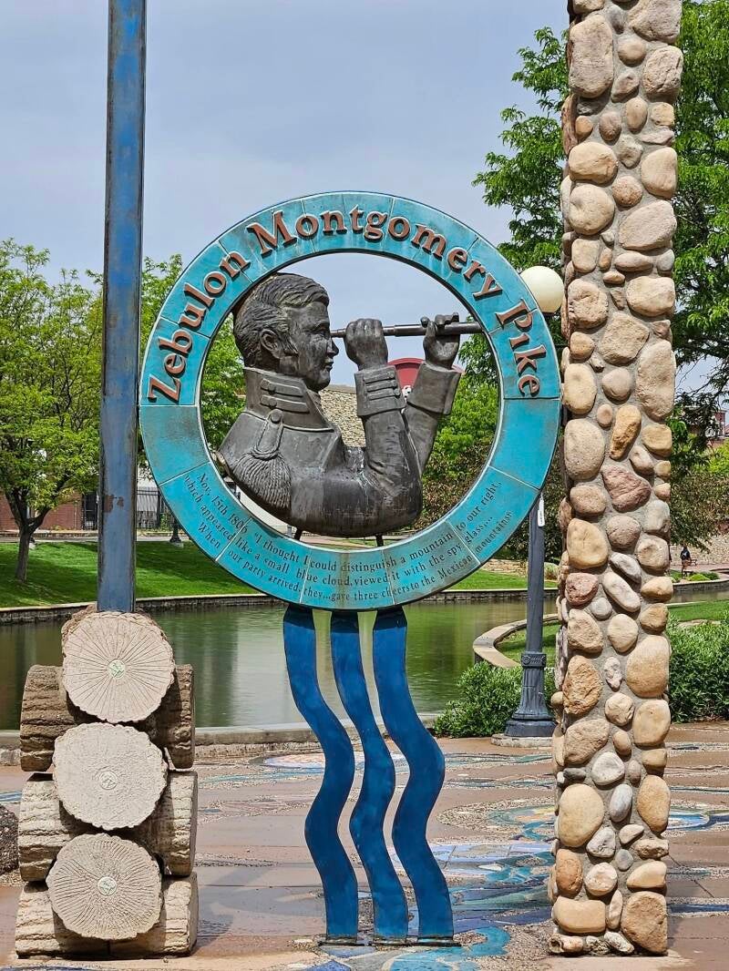
A placard dedicated to Zebulon Pike at the Pueblo River Walk in Pueblo, CO. This is the presumed area where Pike first laid eyes on what is now Pike's Peak.
It was about 125 years ago when Kathy Lee Bates wrote the poem that would become the song America, the Beautiful. Bates's inspiration came from her view from the summit of Pike's Peak while on a day trip with her fellow colleagues from Colorado College. It doesn't come as a surprise how inspired Bates became after seeing the world from so high above. If you've never been to the summit of Pike's Peak, it truly is a site to see the amber waves of grain to your east and the purple mountain majesty to your west. On clear days, indeed you can see as far east as Kansas. Growing up on the plains of eastern Colorado, I could see Pike's Peak on clear days as well from my backyard, and that was 130 miles from the summit. Pike's Peak is located on the very front edge of the Rocky Mountain range, but it stands out because it appears as if it's standing alone when you're looking at it from the east. It's amazing what a clear day outside can expose to the naked eye.
Bates wasn't the only individual to stand in awe of America's peak. After all, the peak is named after the explorer who ventured with his own posse of comrades to the peak in an attempt to reach the summit 100 years before Bates would write America the Beautiful. Zebulon Pike was a frontiersman, explorer and general in the American Army in the early 1800's. He played a crucial role in exploring the southwestern portion of the Louisiana Purchase Territory in 1806 after being promoted to captain in the Army at the age of 27. Pike and his men ventured across what is now modern-day Nebraska, Kansas, Colorado and New Mexico from July 15, 1806, to July 1, 1807. If you've been across this region of the country, not much has changed about the landscape. Pike actually mistook the Great Plains as a desert when in reality the Great Plains is a massive never-ending grassland. In all fairness, when the cold weather turns the grassland brown, this area does appear to look like a desert.
Pike's expedition encountered several mistakes in the nearly year-long journey across the Great Plains and Rocky Mountains. Considering that the eastern portion of the United States is relatively flat with some rolling hills scattered about the terrain, I think it's understandable for the great explorers of the Louisiana Territory to lack understanding of the terrain of the western United States. There isn't a mountain top higher than 8,000 feet east of the Mississippi River. Meanwhile, Colorado alone has more than 50 peaks, including Pike's Peak, with a summit over 14,000 feet in elevation. Not to mention the fact that elevation changes are extreme, going from the flat Great Plains below 5,000 feet to soaring mountain tops of 10,000 feet or more and then back to low river valleys near sea level elevations. At one point, Pike's expedition did a great big loop around the Platte River while they were searching for the source of the Arkansas and Red Rivers, losing valuable time in their expedition.
If you look closely at the plaque in the picture above, the text says that Zebulon Pike first set sight on the grand peak on November 15, 1806. This plaque is located along the Historic Arkansas Riverwalk just south of Main Street in downtown Pueblo. Grand Peak is the name Pike gave the mountain upon seeing the peak for himself. Whether this spot along the riverwalk is exactly where Pike first saw the mountain is up for debate. All we know is he was somewhere in southeast Colorado, presumably around Pueblo. Upon seeing this grand peak, Pike decided that he was going to try and climb to the summit. Now, keep in mind, it's the middle of November by this time. November is not exactly the warmest month of the year in the northern hemisphere. In fact, the Rocky Mountains can receive snow accumulation anywhere starting as early as September some years and going as late as June. Snow can stay on the mountaintop's year-round, too. I've seen this for myself at the summit of Pike's Peak in July. At 14,000 plus feet in elevation, the weather does not warm up like it does at 10,000 feet and below.
Nonetheless, Pike and his crew took a detour north to the mountain. As they would find out, however, getting to the top was too treacherous for the time of year. He never made it to the summit. It's believed that the closest he got to the summit was nearby Mt. Rosa, southeast of the grand peak. Rumor has it that he and his crew were trekking through waist deep snow while being in unproper attire for the snowy, cold weather. Unfortunately, internet research of this specific portion of the expedition is vaguely detailed at best. I only remember details from taking Colorado history throughout public school, but even then, compared to the bigger picture of Pike's second expedition the journey to Pike's Peak is a small sliver of the pie that doesn't get the same amount of attention as the rest of the expedition, specifically the part where the explorers accidentally wondered into Spanish territory in southern Colorado and proceeded to get captured by the Spanish.

Mt. Rosa's location relative to the actual location of Pike's Peak.
Pike's attempted journey to reach the 14,115-foot summit of the grandiose mountain he laid eyes on from roughly 70 miles to the south is a small portion of what the overall expedition was about. Yet he was in awe of the beautiful peak in such a way that a part of him was willing to die if it meant he made it to the top. Luckily for Kathy Lee Bates she didn't have to endure the hardships like improper clothing protection and frost bite to get to the top almost 100 years later. I suppose there is truly something remarkable about a mountain this high in elevation to the eye when nothing like it has been seen before.
Today, visitors to Pike's Peak have a few options when it comes to reaching the summit. Visitors can either drive, take the Pike's Peak Cog Railway or hike their way to the top like Pike himself attempted. The hike includes overnight camping along the trail since it takes multiple days to reach the summit from the base. If you're up for the physical challenge, I've heard nothing but positive reviews from others who've hiked the trail all the way through. You will need to stay hydrated as you go up and down in elevation, however, so be sure to bring plenty of water with you. This advice goes for the Rocky Mountains as a whole. Altitude sickness is not an enjoyable experience. If the road to the summit is open, I would recommend purchasing a day pass to go to the summit, which is open year-round. Adult admission (16 years and older) is $10 per adult, $5 per child between the age of 5 and 15, or $35 for a carload of more than five passengers. A timed entry ticket costs $2, with the uphill gate opening at 9 AM and the last entry at 3 PM. The Cog Railway tickets start at $70. You can reference the website here for additional information including road conditions and the phone number to call for real time updates on the weather conditions.
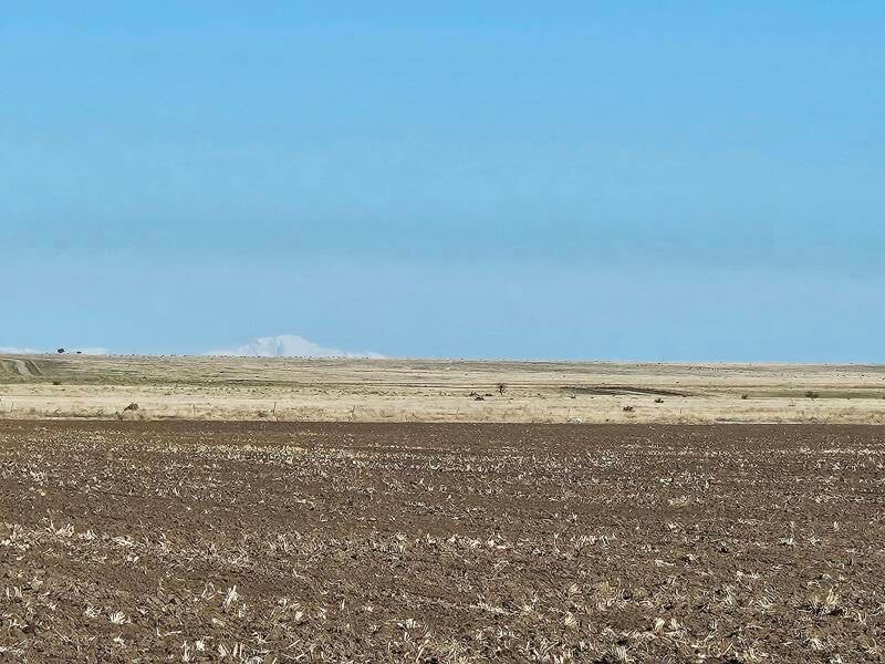
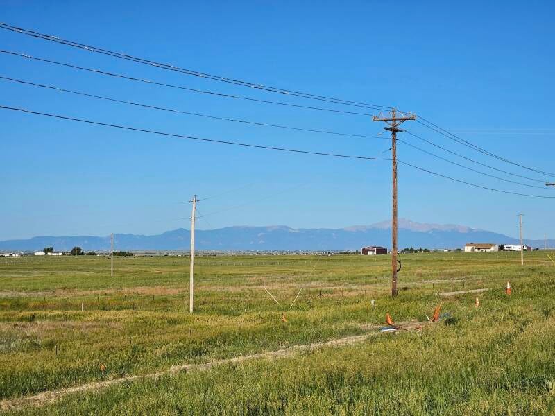
Left to right: View of Pike's Peak from Highway 71, south of Limon (115 miles from base of summit) in May of 2024; View of Pike's Peak from Highway 24, west of Calhan in June of 2025.
Add comment
Comments